


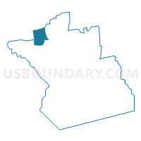
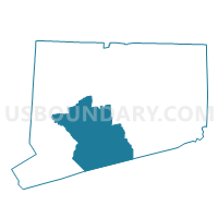
Middlebury 1 Voting District, New Haven County, Connecticut
About
Outline

Summary
| Unique Area Identifier | 550060 |
| Name | Middlebury 1 Voting District |
| County | New Haven County |
| State | Connecticut |
| Area (square miles) | 18.45 |
| Land Area (square miles) | 17.75 |
| Water Area (square miles) | 0.69 |
| % of Land Area | 96.23 |
| % of Water Area | 3.77 |
| Latitude of the Internal Point | 41.52469120 |
| Longtitude of the Internal Point | -73.12301620 |
Maps

Graphs
Select a template below for downloading or customizing gragh for Middlebury 1 Voting District, New Haven County, Connecticut


Neighbors
Neighoring Voting District (by Name) Neighboring Voting District on the Map
- Naugatuck 1-2 Voting District, New Haven County, CT
- Naugatuck 1-3 Voting District, New Haven County, CT
- Oxford 1 Voting District, New Haven County, CT
- Southbury 4 Voting District, New Haven County, CT
- Waterbury 71-1 Voting District, New Haven County, CT
- Waterbury 71-3 Voting District, New Haven County, CT
- Waterbury 73-1 Voting District, New Haven County, CT
- Watertown 68-03 Voting District, Litchfield County, CT
- Woodbury 1 Voting District, Litchfield County, CT
- Woodbury 2 Voting District, Litchfield County, CT
Top 10 Neighboring County Subdivision (by Population) Neighboring County Subdivision on the Map
- Waterbury town, New Haven County, CT (110,366)
- Naugatuck town, New Haven County, CT (31,862)
- Watertown town, Litchfield County, CT (22,514)
- Southbury town, New Haven County, CT (19,904)
- Oxford town, New Haven County, CT (12,683)
- Woodbury town, Litchfield County, CT (9,975)
- Middlebury town, New Haven County, CT (7,575)
Top 10 Neighboring Place (by Population) Neighboring Place on the Map
Top 10 Neighboring Unified School District (by Population) Neighboring Unified School District on the Map
- Waterbury School District, CT (110,366)
- Naugatuck School District, CT (31,862)
- Regional School District 15, CT (27,479)
- Watertown School District, CT (22,514)
- Regional School District 14, CT (13,582)
- Oxford School District, CT (12,683)
Top 10 Neighboring State Legislative District Lower Chamber (by Population) Neighboring State Legislative District Lower Chamber on the Map
- State House District 131, CT (25,985)
- State House District 71, CT (24,975)
- State House District 66, CT (23,493)
- State House District 68, CT (23,431)
- State House District 73, CT (23,420)
- State House District 69, CT (23,274)
Top 10 Neighboring State Legislative District Upper Chamber (by Population) Neighboring State Legislative District Upper Chamber on the Map
- State Senate District 32, CT (101,305)
- State Senate District 15, CT (96,274)
- State Senate District 17, CT (95,979)
Top 10 Neighboring 111th Congressional District (by Population) Neighboring 111th Congressional District on the Map
- Congressional District 5, CT (714,296)
- Congressional District 3, CT (712,339)
- Congressional District 4, CT (706,740)
Top 10 Neighboring Census Tract (by Population) Neighboring Census Tract on the Map
- Census Tract 3602, Litchfield County, CT (7,765)
- Census Tract 3454, New Haven County, CT (7,134)
- Census Tract 3453, New Haven County, CT (6,455)
- Census Tract 3461.02, New Haven County, CT (6,009)
- Census Tract 3604, Litchfield County, CT (5,996)
- Census Tract 3621.02, Litchfield County, CT (5,816)
- Census Tract 3520, New Haven County, CT (4,920)
- Census Tract 3441, New Haven County, CT (4,856)
- Census Tract 3481.22, New Haven County, CT (4,349)
- Census Tract 3518, New Haven County, CT (4,252)
Top 10 Neighboring 5-Digit ZIP Code Tabulation Area (by Population) Neighboring 5-Digit ZIP Code Tabulation Area on the Map
- 06770, CT (31,975)
- 06708, CT (29,418)
- 06488, CT (19,904)
- 06795, CT (14,144)
- 06478, CT (12,683)
- 06798, CT (9,984)
- 06762, CT (7,561)